


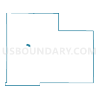
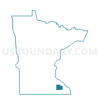
Rochester W-2 P-5, Olmsted County, Minnesota
About
Outline

Summary
| Unique Area Identifier | 603433 |
| Name | Rochester W-2 P-5 |
| County | Olmsted County |
| State | Minnesota |
| Area (square miles) | 0.59 |
| Land Area (square miles) | 0.59 |
| Water Area (square miles) | 0.00 |
| % of Land Area | 100.00 |
| % of Water Area | 0.00 |
| Latitude of the Internal Point | 44.03465500 |
| Longtitude of the Internal Point | -92.52733000 |
Maps

Graphs
Select a template below for downloading or customizing gragh for Rochester W-2 P-5, Olmsted County, Minnesota


Neighbors
Neighoring Voting District (by Name) Neighboring Voting District on the Map
- Cascade Twp. P-3, Olmsted County, MN
- Rochester W-2 P-3, Olmsted County, MN
- Rochester W-2 P-6, Olmsted County, MN
- Rochester W-3 P-1, Olmsted County, MN
- Rochester W-3 P-3, Olmsted County, MN